
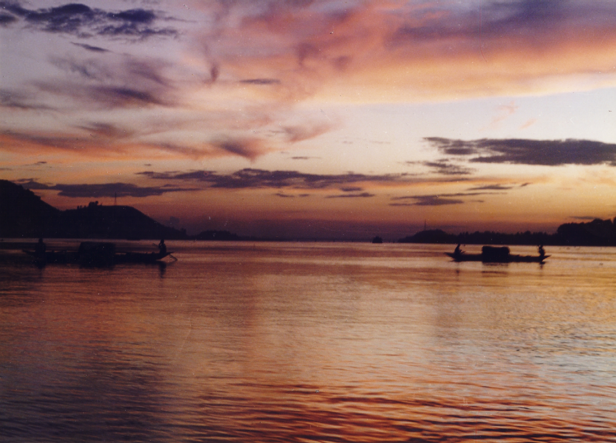
The Brahmaputra, the lifeline of northeast India is undoubtedly one of Asia’s most magnificent rivers. This river which is almost 3000 km long, is known by different names in the three countries it flows through (China, India, and Bangladesh). Its uniqueness also lies in the fact that it represents and bridges three major religions: Hinduism, Buddhism, and Islam, making it a virtual cultural consommé. Nothing can prepare the traveler for the vastness of this great water highway, where myriad channels ply through seemingly endless archipelagoes of sand.
The Brahmaputra is one of the few masculine rivers in India. This gender classification has resulted mainly from its sheer size and the strength of its currents, especially during the monsoon. In the tradition of Sanskrit literature, the sea is considered masculine while a river is usually feminine. In this context, it is important to note that Lauhitya (Brahmaputra) in ancient times was often referred to as a sea.
The origin of the Brahmaputra is associated with several legends. According to one story, Sage Shantanu and his wife took abode on Mount Gandhamadana. Brahma called upon the sage, who was away at the time gathering fruits and flowers in the forest. Brahma’s eyes fell on Amogha, the sage’s exquisitely beautiful wife who failed to recognize him. Enamored by her beauty, he wanted her to bear his child. Amogha declined Brahma’s overtures and even threatened to curse him if he dared to molest her. Saddened, Brahma returned home to ‘Brahmalok’ leaving his seminal fluid behind. The sage heard about Brahma’s visit on his return. Using his divine powers, he learned that Brahma’s proposition was for the benefit of the universe. He then requested his wife to comply with the lord’s wishes, but the chaste Amogha refused. The sage then infused the fluids left behind by Brahma and thereafter the union between him and his wife produced a child who was born as a shimmering watery form, with features resembling Brahma. They called him Brahmakunda and placed him between four mountains-Kailash, Gandhamadana, Jarudhi, and Sambwarttaka. Over time, this water body grew into a lake swelling up to forty miles, resembling the sea. It’s said that Brahma descended on his swan mount to bless this child and named him Lauhitya Ganga; however, as he was Brahma’s son (Putra in Sanskrit) he earned the nickname ‘Brahmaputra’. The numerous tributaries that feed the Brahmaputra rise in the Himalayan glaciers of western Tibet near Mount Kailash. Running east through Tibet, past the mountain mass of Namcha Barwa near the “Great Bend” of the Tsangpo (the main river of southeastern Tibet) they continue their tortuous journey through impossibly deep gorges before turning south towards India. After a gradual descent, the tributaries enter the remote northeastern state of Arunachal Pradesh as the Dibang, Siang and Lohit rivers, which finally merge in the Assam Valley to form the Brahmaputra River.
On entering Assam, the Brahmaputra becomes braided. The river and its numerous tributaries from the massive flood plains of the Brahmaputra Valley, where the span of the river can reach almost 20 km, making it one of the widest rivers on the planet. Between Dibrugarh and Lakhimpur, the river splits into two separate channels-the northern Kherxhutia and the southern Brahmaputra. These two channels merge 100 km downstream encircling Majuli, one of the largest freshwater islands in the world.
During the monsoon when the Brahmaputra is in spate, it appears as a ceaseless expanse. Between June and October, floods are a common occurrence. Deforestation of the Brahmaputra watershed has resulted in soil erosion, increasing the probability of flash floods. The normally clear water becomes a swirling mass, colored red by the topsoil which is deposited in the fertile delta during its final journey. Locals associate the color with a popular legend. According to the Puranas, the mighty Brahmaputra and the region around it was called ‘Lauhitya’ or the ‘river of blood’ It is believed that the Hindu sage Parasurama washed his bloody ax in these waters after committing matricide, staining it eternally.
Periodic flooding, which helps replenish the fertile soil of the river valley is also responsible for great misery. But when the roads along the river are rendered un-motorable, the river highway of the Brahmaputra provides a welcome respite to the besieged people of the valley. The people in the Brahmaputra valley are used to this endless cycle of destruction and resurrection and have adapted well!
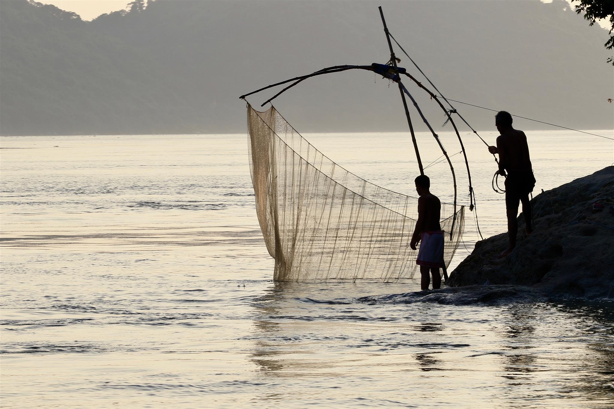
The boat is an emblematic representation of the river people’s endless struggle against the elements. During the warm and wet months, when entire villages are marooned, the Brahmaputra (navigable for almost 1,285 km upstream) allows vital supplies to be transported. The floating river ports on the Brahmaputra are characteristic of this region. Every manmade structure on the river, which includes markets and restaurants, is supported by barges to account for large variations in tidal levels. Surprisingly, for a river with such great religious and mythological significance, there are very few centers of pilgrimage along its banks. Parasuramkund on the Lohit River, (one of the tributaries of the Brahmaputra) is associated with the warrior sage Parasurama. It attracts millions of devotees who congregate here during the Hindu festival of Makar Sankranti (mid-January) when a big fair is held. Before the devastating earthquake which struck the region in 1950, Parasuramkund (or Brahmakund) was almost ringed in by a rocky wall that gave it the appearance of a small lake. The earthquake destroyed this natural dam and today the mighty river roars past a rickety bamboo fence that protects the pilgrims from the might of Brahma’s son.
Guwahati, in the river’s middle course, has numerous hill shrines, the most important being the 16th-century Kamakhya Temple that is dedicated to the mother goddess and her various incarnates. This is the seat of tantric worship in northeast India and the day usually begins with animal sacrifices to appease Kali, a Hindu goddess associated with eternal energy. Hajo, 24 km from Guwahati is the best example of the Brahmaputra’s multi-religious makeup. This ancient pilgrimage center caters to the spiritual needs of three religions: Hinduism, Buddhism, and Islam. Just off Guwahati lies Peacock Island. On this stunted hillock in the middle of the Brahmaputra stands the 16th-century Umananda Temple dedicated to Shiva and his consort Uma. The temple is not the only attraction here; the island has a resident troop of Golden Langurs who enjoy the company of human beings.
Majuli near Jorhat was the center of the Neo-Vaishnavite movement. Until the 15th century, most people in Assam belonged to non-Aryan tribes who believed in animism and nature worship. Even in an organized religion like Hinduism, caste hierarchy encouraged violence and disunity. Since the 12th century, an experimental social reformist movement was making inroads across the country and slowly gaining acceptance. The Bhakti sect was born from Hinduism, but it was based on the liberal doctrine of Bhakti, or devotion. This movement gave birth to new ideas, even new faiths, and the Neo-Vaishnavite movement was born out of this experiment. In Assam, the proliferation of this movement is generally attributed to the social reformer and writer Srimanta Sankardeva. In the latter part of the 15th century, he ushered in a socio-cultural renaissance. Humanists in content and popular in form, it was incorporated in literature as well as the arts. This tradition still survives on the island of Majuli. Of the 46 major satras, only 26 remain today, most of which date back to the 16th century.
Today, many islands and villages along the Brahmaputra face extinction, but the river that has a reputation for being destructive also creates new landmasses. The landscape here is in a constant state of change. In unorganized settlements along the Sunderbans where the delta is vast, this does not seem to matter. People are nomadic and well-attuned to this predicament. Every monsoon, they shift their temporary residence and are constantly on the move, much like the river. But in an organized settlement like Majuli which has been shrinking continuously due to soil erosion, the socio-economic problem of resettlement becomes acute. The erratic nature of the river is best seen downstream, in Palashbari, approximately 30 km from Guwahati.
India is a country where the monsoon is normally associated with joy and celebration, but for the people of Palashbari, this is a season of sorrow. Every year, the river swallows a few kilometers of land here, while depositing silt on the opposite bank. Many residents have lost their agricultural land and have been forced to migrate to urban areas in search of work due to this crisis.


